“Tracking for Freedom”: Longest trip so far

Today, I went for my longest trip so far this season, which was about 75 km. Once more, I was with a group of people from TriTeam Chaos. The track itself was already well-known to me, so there’s nothing interesting to report, except maybe for the fact that my bike computer is now working again and it even shows my cadence.
Once more, I’m asking you to think about supporting my little fundraising project. I’d also be very happy if asked anybody you know who might support this. Some companies also have so-called matching gifts programs which double the employees’ donations to charities :-)
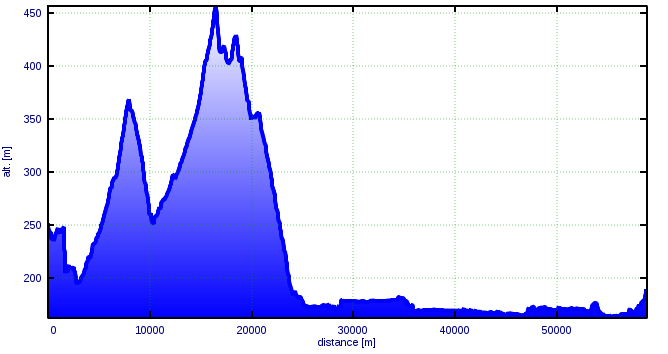
The usual numbers:

Total distance 75.2 km
Average speed 26.0 km/h
Maximum speed 51.8 km/h
Total climb 307 m
Average heart rate 152 bpm
Maximum heart rate 202 bpm
Average cadence 61 rpm
Time active 02:53:19
Time resting 00:16:57
Energy consumed 1604 kcal

Note: The climb was measured using a non-calibrated barometric altimeter; the amount of energy consumed was calculated from the measured heart rate and physiological parameters.

The GPX file recorded during this trip can be found here.

Read more about the “Tracking for Freedom” project here. All blog posts about the project are tagged Tracking for Freedom.

“Tracking for Freedom”: Systems integration test, partly failed

Yesterday, I did my first ride after installing my new €5 cadence sensor and connecting it to my bike computer. I wanted to go for a short trip and when I left home, I assumed that I’d be alone. I was wrong. After about one kilometre, I met one of the triathletes from TriTeam Chaos who told me that he’d meet two other guys for a training trip. I went with them until Greifenstein, but then I returned because joining people whose stamina is about 100% higher than your own is rather exhausting :-)
In general, the trip was pleasant because I returned before it started to rain. The only negative thing was that this trip was meant to show that the cadence sensor and the bike computer work together. They did so for the first four kilometres, but then all of a sudden, the bike computer failed to display the speed (the cadence was still shown). Today, I disassembled everything and found the reason: The cable connecting the bike computer to the speed sensor was torn. Since I couldn’t find a replacement part, I tried to fix it myself. Those who know me a bit better know I’m not a very handy person, but nonetheless, I managed to connect the cable again! The funny thing is that I explicitly bought a wired bike computer because I feared that the sensor’s battery could fail at any time without warning. Now I know that something similar can also happen with a wired sensor :-(
Because of this hardware problem, the data below comes from my Forerunner 405 (which I’m about to replace with a Forerunner 910XT with a wireless cadence sensor!).

The usual numbers:

Total distance 48.4 km
Average speed 26.5 km/h
Maximum speed 43.9 km/h
Total climb 237 m (I doubt this, I think it was less)
Average heart rate 165 bpm
Maximum heart rate 202 bpm
Time active 01:49:27
Time resting 00:23:33
Energy consumed 1939 kcal

Note: The climb was measured using a non-calibrated barometric altimeter; the amount of energy consumed was calculated from the measured heart rate and physiological parameters.

The GPX file recorded with my eTrex can be found here.

Read more about the “Tracking for Freedom” project here. All blog posts about the project are tagged Tracking for Freedom.

“Tracking for Freedom”: Climbing the hills from the other side

Yesterday, I went for another trip. My original plan was to go along a similar route as on my last trip with TriTeam Chaos, but from the other direction and with a slightly smaller distance of about 53 km. Instead of climbing Exelbergstraße in the 17th district, I went for a route via Sievering, which is part of the 19th district. Once more, the climb (see the elevation profile below) was extremely exhausting and I almost gave up. However, when I reached the highest point of my planned route, I decided to change the route a little bit so I would actually go back a longer way. In the end, I even went around the block once more to reach exactly 60 km. I was extremely tired by then I’m not sure if I can make another trip that long in the near future. If you want to help raise my motivation and support my health and Free Software all at once, please donate to FSFE using the “Tracking for Freedom” as the payment reference. If you are new to the whole project of “T4F”, read more about it here.

Elevation profile

The trip's elevation profile

Note: At the very left, the altitude is definitely wrong. It seems the barometer delivered incorrect data during the first 15 minutes or so. This might also influence the total climb measured.


The usual numbers:

Total distance 60.0 km
Average speed 24.5 km/h
Maximum speed 66.5 km/h
Total climb 535 m
Average heart rate 157 bpm
Maximum heart rate 192 bpm
Time active 02:32:00
Time resting 00:05:27
Energy consumed 2477 kcal

Note: The climb was measured using a non-calibrated barometric altimeter; the amount of energy consumed was calculated from the measured heart rate and physiological parameters.

The GPX file recorded with my eTrex can be found here.

“Tracking for Freedom”: Close to the fine line

Most of you probably know that there is a fine line between genius and insanity. I think there’s probably no place that reflects this fact better than the small village of Maria Gugging, right outside of Vienna. Today, I did a very light climbing training and passed this town, which used to be the home of a mental hospital, but today the Institute of Science and Technology, which is an institute of basic research (sometimes referred to as “elite university” by the Austrians) that tries to hire the best scientist from all over the world, is located right at the same place. Unfortunately, my eTrex ran out of battery pretty exactly at the spot of maximum altitude of this tour. This is why the GPX file about this trip was recorded with my Forerunner. Before I started, I added another centimeter of height to my saddle’s position, following Alex Kolar‘s advice. I didn’t feel much difference, but since he’s the expert, it was probably a good decision. Maybe I’ll have to do more adjustments in the future. When I went out on the street with my bike, the first thing I realised was a pretty heavy wind. Also, the sky was rather cloudy and everything felt like an upcoming shower. I first wasn’t sure if I should start at all, but then, what’s the price for freedom? So I went for the trip nonetheless, and I actually enjoyed it very much because the temperature was quite comfortable and even when the wind became extremely strong from time to time, it was not as bad as I had feared. I returned home rather late and I was quite thankful for my decision to put a basic illumination to my bike.

The usual numbers:

Total distance 49.0 km
Average speed 25.8 km/h
Maximum speed 54.4 km/h
Total climb n/a (eTrex failed)
Average heart rate 163 bpm
Maximum heart rate 191 bpm
Time active 01:53:55
Time resting 00:11:05
Energy consumed 1940 kcal

Note: The amount of energy consumed was calculated from the measured heart rate and physiological parameters.

The GPX file recorded with my Forerunner can be found here.

p.s. If you don’t have an offline GPX viewer, you can view the file here. Caution: The tool used on this site is not 100% free because using it on commercial sites requires the author’s permission (see here (German) for the legal details). Unfortunately, it also defaults to use Google Maps, but you can switch to OSM, which I recommend.

“Tracking for Freedom”: Survived the hills

Today, I finally managed to go for another trip for the “Tracking for Freedom” trip. I was once again with the guys from TriTeam Chaos, but this time we were even eight people. The beginning of the trip was very nice, I even had the engery to chat with some of the other participants. Later, we went up to the hills of the Wienerwald and I painfully realized that I am not (or at least not yet) a climber. I was definitely the slowest member of the group and others even had time to go up the hills twice while I was still fighting myself. I’m proud that I never had to stop and push my bike. I have attached the evelation profile of the trip to this post.

Evelation profile

The trip's elevation profile


The usual numbers:

Total distance 61.0 km
Average speed 22.7 km/h
Maximum speed 54.8 km/h
Total climb 539 m
Average heart rate 155 bpm
Maximum heart rate 197 bpm
Time active 02:41:30
Time resting 00:33:29
Energy consumed 2451 kcal

Note: The climb was measured using a non-calibrated barometric altimeter; the amount of energy consumed was calculated from the measured heart rate and physiological parameters.

The GPX file recorded with my eTrex can be found here.

“Tracking for Freedom”: Cycling with the pros

Today, I did another trip for the “Tracking for Freedom” project and for the first time, I was not alone. Three triathletes from TriTeam Chaos allowed me to join them on their bicycle tour. They taught me slipstreaming and I owe them a big thank you for taking me with them. I think I have never had a higher average speed on one of my tours. The track was already familiar with me, but I have never followed it so far in the past. Of course I’m not in the shape to go for a whole tour with professional triathletes, so I had to return earlier than the others.

The usual numbers:

Total distance 67.7 km
Average speed 27.7 km/h
Maximum speed 40.8 km/h
Total climb 213 m
Average heart rate 167 bpm
Maximum heart rate 194 bpm
Time active 02:20:12
Time resting 00:26:34
Energy consumed 2532 kcal

Note: The climb was measured using a non-calibrated barometric altimeter; the amount of energy consumed was calculated from the measured heart rate and physiological parameters.

The GPX file recorded with my eTrex can be found here.

“Tracking for Freedom”: Not the best route chosen

Today, I finally managed to do my second cycling trip for the “Tracking for Freedom” project. While I originally wanted to follow the Danube southbound and return the same way, I managed to take the wrong path at some point and so I improvised the remaining route. Instead of returning via the Donauinsel, I crossed the Danube at the Freudenau power plant and drove across Simmering and the central cemetery. Afterwards, chose the “Zweierlinie” from Karlsplatz to Vienna’s Landesgericht. This last part however proved to be a rather bad decision. There were lots of rather slow cyclists on the bike lane and so my average speed went down quite fast. Of course I could have chosen the car lane, but I’m not tired of life.

Some figures:

Total distance 46.6 km
Average speed 22.8 km/h
Maximum speed 40.4 km/h
Total climb 251 m
Average heart rate 153 bpm
Maximum heart rate 183 bpm
Time active 02:00:43
Time resting 00:18:52
Energy consumed 1985 kcal

Note: The climb was measured using a non-calibrated barometric altimeter; the amount of energy consumed was calculated from the measured heart rate and physiological parameters.

The GPX file recorded with my eTrex can be found here.

“Tracking for Freedom”: First trip

Today I went for my first “Tracking for Freedom” trip. Having not used my bike for almost half a year, it was pretty exhausting. I probably should have chosen a shorter distance. The first 20 kilometres were very nice and I didn’t have any problems. After changing from the left to the right riverside of the Danube in Greifenstein, I decided to return to Vienna via the Wienerwald instead of following the right river bank. The climb to Maria Gugging turned out to be quite exhausting and it also lowered my average speed. The following descent however was very nice. Nonetheless, my legs were tired and so the last kilometres from Klosterneuburg back to Vienna were rather painful.

Some figures:

Total distance 58.1 km
Average speed 24.0 km/h
Maximum speed 43.98 km/h
Total climb 312 m
Average heart rate 155 bpm
Maximum heart rate 184 bpm
Time active 02:23:15
Time resting 00:12:09
Energy consumed 2202 kcal

Note: The climb was measured using a non-calibrated barometric altimeter; the amount of energy consumed was calculated from the measured heart rate and physiological parameters.

The GPX file recorded with my eTrex can be found here.

Survived! (and enjoyed it)

I know I’m a bit late, since Matthias already wrote about our successful, adventurous weekend, but still I want to to tell you all how much I enjoyed our time together in Vienna. After I almost arrived late a Vienna International Airport’s arriving hall (which was because I was told there were 78 free lots on my floor in the car park, although there were none), everything else (except for the weather on Saturday) went very well.
The meeting of the Vienna Fellowship group was well-attended, although in summer we usually have less participants. I’m quite sure that this was solely because of Matthias’ good Karma. After some hours of interesting discussions, we had late-night dinner (which we have at almost all Vienna Fellowship meetings) and left the Metalab some time after midnight.
Nevertheless, we got up rather early on Saturday to discuss our plans and ideas about the Fellowship and then start our mental preparations for the Temple of Schnitzel. Below you can find a picture of what we found there.
The few heros who had survived Schnitzelwirt then did some sight-seeing in Vienna and bought some traditional Viennese items to pay compensation to Matthias’ “better half”. We also visited Vienna’s most popular Würstelstand and in the evening went to a very nice Karaoke bar. Despite the fact that Peter’s girlfriend Jenny had an indisputable home field advantage there, almost all of us showed more or less singing talent (and skill to make fun of ourselves).
Sunday then was our relaxation day and Matthias left for Berlin again, where I hope to visit him in the near future.

A Schnitzel named Jack

A Schnitzel named Jack

First Fellowship meeting in Graz

On Thursday June 18 the first Fellowship meeting in Graz took place. The meeting was combined with the meeting of the realraum group and we had quite a few people there. The realraum guys offered that we could use their rooms for our meeting and told us that they are happy about every event taking place there. Since the realraum project has similar goals as the Metalab where the meetings in Vienna take place I liked the idea very much and we decided that for the time being the Graz Fellowship group will combine the Fellowship meetings with the realraum meetings.
At the beginning of the meeting, I gave a short speech to introduce the FSFE and the Fellowship to non-Fellows. After I had told the story of the Freedom Task Force and its activities, a discussion about Free Software Licenses arose and the amazing interest in the legal aspects of Free Software led me to the suggestion to invite someone from the FTF to make a speech on that topic. Since many of the attendees criticised that the IT studies at Graz University of Technology do not offer any courses on legal aspects of information technology, it was proposed to combine the speech with a course called “Social aspects of information technolgy” where the student council can influence the course contents.
I like this idea very much and will keep you updated which new information on that topic. I also hope we will find more topics to cover with speeches since most of the meeting’s attendees said they would like to raise public awareness on Free Software topics.