Yesterday, I went for another trip. My original plan was to go along a similar route as on my last trip with TriTeam Chaos, but from the other direction and with a slightly smaller distance of about 53 km. Instead of climbing Exelbergstraße in the 17th district, I went for a route via Sievering, which is part of the 19th district. Once more, the climb (see the elevation profile below) was extremely exhausting and I almost gave up. However, when I reached the highest point of my planned route, I decided to change the route a little bit so I would actually go back a longer way. In the end, I even went around the block once more to reach exactly 60 km. I was extremely tired by then I’m not sure if I can make another trip that long in the near future. If you want to help raise my motivation and support my health and Free Software all at once, please donate to FSFE using the “Tracking for Freedom” as the payment reference. If you are new to the whole project of “T4F”, read more about it here.
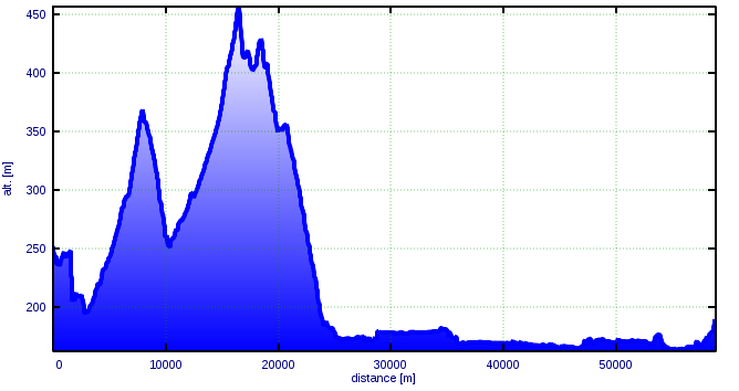
The trip's elevation profile
Note: At the very left, the altitude is definitely wrong. It seems the barometer delivered incorrect data during the first 15 minutes or so. This might also influence the total climb measured.
The usual numbers:
| Total distance | 60.0 km |
|---|---|
| Average speed | 24.5 km/h |
| Maximum speed | 66.5 km/h |
| Total climb | 535 m |
| Average heart rate | 157 bpm |
| Maximum heart rate | 192 bpm |
| Time active | 02:32:00 |
| Time resting | 00:05:27 |
| Energy consumed | 2477 kcal |
Note: The climb was measured using a non-calibrated barometric altimeter; the amount of energy consumed was calculated from the measured heart rate and physiological parameters.
The GPX file recorded with my eTrex can be found here.